Using Technology to Enhance Planning & Engineering Outcomes
Municipal governments rely on data most of which has some type of spatial component. Geographic Information Systems (GIS) is a tool that the public sector can use to transform the way assets are organized, communities are planned, and ordinances are developed. Applications based on this information can also improve the effectiveness, efficiency, and accuracy of staff. Incremental investments into a community’s GIS allow the expansion of database information for asset management, to improve assessments, and better maintain a community’s above- and below-ground facilities. The powerful combination of GIS, AutoCAD, and laser scanning can also enhance decision-making for planning, zoning, and historic preservation.
Public Works
Many communities are developing asset management plans to ensure viable long-term maintenance and track their facilities and infrastructure. Often, however, these asset management plans are based on a series of disconnected maps and paper records. So the first step in any asset management strategy is creating an accurate and efficient database that is tied to geographic locations in the community. An obvious benefit of having an interactive map-based display of water, sewer, roads and other community assets is that this platform conveys a considerable amount of information in a highly usable and accessible format. The ability to view a dynamic geographical interface can replace thousands of pages of plans and spreadsheets. With interactive GIS mapping, municipalities can not only see what assets they have, they can identify which assets are in need of maintenance or replacement at a glance. These maps can then serve as the basis for required capital improvement plans (CIP), short– and long-term capital budgeting and rate forecasting. They can also educate the community about infrastructure revenues and expenditures.
Community Planning
GIS platforms offer alternative channels for public input and education. These tools can be used to help communities reach out to residents and business owners who may not typically attend meetings as well as to obtain geography-specific and visual information that letters, emails and oral comments cannot convey. Two examples of using GIS-based platforms include:
-
PictureThis!™
The City of Ann Arbor is updating its sign ordinance to include sign standards that reflect evolving technologies and approaches as well as a general update of sign regulations. Residents and business owners were invited to participate in an online platform to better understand how residents and business owners think the current sign ordinance is working and what may need work. Images of signs that seem creative, effective, and attractive, or distracting, bland, and ineffective were submitted from an internet browser using the user’s phone, tablet, or computer. The resulting images have been useful in understanding what the community thinks of its signage.
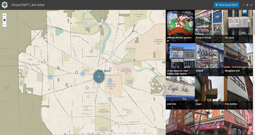
Picture This!™ allowed Ann Arbor residents and business owners to upload images of signs that they liked and disliked. This platform has been a useful tool as the city updates its sign ordinance.
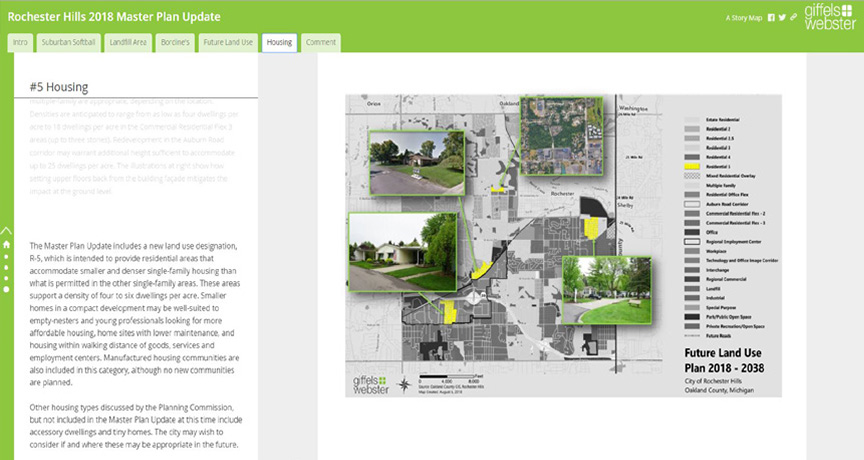
This GIS-based online platform offered the public an alternative way to participate in the master plan process in Rochester Hills.
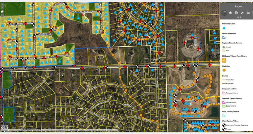
This Washington Township infrastructure map illustrates where water & sewer customers are located, which is useful for ongoing maintenance and future connectivity.
-
Master Plan Engagement
For the City of Rochester Hills 2018 Master Plan Update, in addition to a public open house, we created a “Virtual Open House” using GIS-based story maps to offer residents and business owners that were not able to attend the physical open house an opportunity to provide their input online to the same information presented at the physical open house. The story map included a survey that also asked the same questions asked at the open house regarding specific redevelopment sites, the proposed future land use plan, and housing. By using the online-based story maps, the city was able to reach out to more residents in order to get additional public feedback towards creating the Master Plan Update.
Legislation to Watch – Small Cell Systems
Last year, Michigan Senate Bill 637 was introduced on behalf of the telecommunications industry with the goal of streamlining the deployment of small cell technology. Small cells consist of radio equipment and antennas that are typically placed on their own on structures such as utility and street light poles in order to bolster 5G networks. Small cells are lower-power cell sites placed at much closer intervals than cell towers typically placed miles apart. The bill defines “small cell wireless facility” as having each antenna located inside an enclosure of not more than 6 cubic feet in volume, or in the case of exposed elements, the antenna and all of its exposed components would fit within an imaginary enclosure of not more than 6 cubic feet.
Part of the stated purpose of the bill is to increase investment in the wireless network to benefit citizens and the state, specifically by providing better access to emergency services, advanced technology, and information. The bill would prioritize the use of existing utility poles and wireless support structures for collocation over the installation of new poles or structures. As currently written, the bill would generally regulate rates and fees charged by state or local government authorities, allow the use of public rights-of-way, regulate certain permitting processes and zoning reviews and prohibit certain commercially discriminatory actions. The bill prohibits state and local government authorities from entering into exclusive arrangements with any person for the right to attach to certain utility poles.
There are several sections within the draft bill that communities should understand pursuant to planning and zoning functions. Within or outside of public right-of-way, the draft bill states that zoning review and approval would be required to modify existing or install new small cell wireless facilities, and the modification of existing or installation of new wireless support structures used for such small cell wireless facilities. Zoning provisions would apply to installations on a utility pole higher than 40 feet in the ROW or any pole outside of the ROW.
The bill provides that a wireless provider may bypass zoning review to collocate small cell wireless facilities and construct, maintain, modify, operate, or replace utility poles in, along, across, upon, and under the ROW subject to:
- A utility pole in the ROW installed or modified on or after the effective date of this act shall not exceed 40 feet above ground level, unless a taller height is agreed to by the authority.
- A small cell wireless facility in the ROW installed or modified after the effective date of this act shall not extend more than 5 feet above a utility pole or wireless support structure on which the small cell wireless facility is collocated.
- Other functions exempt from zoning review include the replacement of a small cell wireless facility with a facility that is not larger or heavier; routine maintenance of a facility, utility pole, or wireless support structures; and the installation, placement, maintenance, operation, or replacement of a micro wireless facility that is suspended on cables strung between utility poles or wireless support structures.
Recreational Marijuana
On November 6, 2018, Michigan voters approved Proposal 1, which permits the use and sale of recreational marijuana. Communities should be aware that this legislation differs from the previous legislation regulating medical marijuana (MMFLA) in that there is an automatic opt-in unless a community specifically opts-out by resolution or ordinance. In addition, the community cannot opt-in for only one type of marijuana facility; once it opts in, they are in for all five types of facilities, including the new facility, the microbusiness. Many communities are considering opting out and prohibiting marijuana establishments by resolution until they can prepare sufficient regulatory language.
Planning & Zoning News from Our Communities:
The final draft of the Master Plan Update is complete for the City of Rochester Hills. The City of Brighton recently adopted new form based zoning standards to encourage housing near downtown. “Missing Middle” housing types that are now permitted in the new R-5 district include courtyard apartments, four-plexes, townhouses and accessory dwelling units. This district falls within a five to ten-minute walk of Brighton’s downtown.
Giffels Webster will help you identify and leverage your unique resources to improve the assets and attractiveness of your community. Whether it is increased walkability and connectivity, better streetscape design and parking, more natural settings and gathering places or other changes to enrich your city, we will work in partnership with you on how to attract and retain businesses and residents.
As your municipal partner, we also review submitted site plans, conduct inspections, maintain records, prepare master plans, lead the planning, and construction administration process for capital improvement projects. For more information please call us at 866.271.9663 and visit www.giffelswebster.com