Waterfront communities have been presented with a new challenge due to the recent volatility of water levels throughout the Great Lakes Basin. The existing infrastructure systems, primarily storm and combined sewer systems, are not designed to take on excessive volumes of river water from flooding. This massive inflow/infiltration into a sanitary system can flood streets, potentially back up sewers into basements, and/or cause too much strain on aging pumps needed to operate the system. Waterfront homes, structures and other properties also are not designed to take on constant flows of water, which could result in premature failure of those facilities. Mitigating the water is a problem that communities need to be prepared for in short- and long-term instances with new, resilient designs.
The Lower East Side (LES) of Detroit, along with other communities along the Detroit River and Lake St. Clair, have experienced significant flooding issues over the past two to three years. Rising water levels within the Great Lakes Basin resulted in severe property damage and millions of gallons of water from the Detroit River overwhelming seawalls and inland canal banks in 2019. Along with the flooding waters in the summer months, FEMA has also provided preliminary updates to the Flood Insurance Rate Maps (FIRM) within the City that would significantly increase the number of properties within the regulated floodplain.
In many areas of the world, the intensity of rainwater is too much for infrastructure to handle. Other areas (i.e. LES) have experienced rising water levels each year that now present problems that never previously existed. Proactive measures would require a large private or public investment in seawalls, other barriers, or unprecedented storm detention systems. In many cases, this isn’t feasible in the short term. Preparing for these emergency situations is likely the most realistic option until significant funding is available and comprehensive, resilient design improvements can be implemented.
In the City of Detroit, based on actual observed levels and United States Army Corp of Engineering (USACE) predictions, it was clear that water levels in 2020 would near a record high, eclipsing the records set just last year. Emergency preventative measures were needed. In general, short-term flood mitigation measures can vary from earthen berms to sandbags and anything in between. Choices can be made based on the space available for protection and price, which makes every situation unique.
Multiple Disciplines Work Together to Solve Jefferson Village Flooding Issue
Having worked with the Economic Development Corporation of the City of Detroit on Jefferson Village for nearly 25 years, Giffels Webster was brought in to assist the City in a coordinated and proactive approach for summer of 2020, when the USACE predicted even higher water levels in the area. Combining multiple disciplines internally, Giffels Webster analyzed flooding from the previous year and performed UAV surveys of the areas, including the Harding Canal, Fox Creek and the canals around Harbor Island and Klenk Island to determine spots most likely vulnerable to flooding in the new year.
Working with the City of Detroit and the USACE, Giffels Webster helped determine the effective elevation needed for protection and further analyzed multiple alternative flood mitigation measures before recommending the installation of more than 5,000 linear feet of Tiger Dams in addition to several hundred feet of Hesco Barriers and some temporary earthen berms. Working directly with the City, the USACE and the manufacturers, Giffels Webster finalized bid documents and facilitated a quote for all materials (including some on loan from the USACE). Giffels Webster also worked closely with the Mayor’s office and other City departments to participate in public engagement at multiple points during the project. During construction, Giffels Webster provided the City of Detroit General Services Department with construction layout and administrative support.
Temporary Solutions Include Natural and Manmade Materials, Plus Program Support
In the Jefferson Village neighborhood of Detroit, the boundary of the Harding Canal is mostly comprised of vacant lots owned by the City, with a few privately owned residential or commercial properties. Because the City did not have a nearterm redevelopment plan for these lots, an earthen berm in the rear of the lots was chosen for most of the flood mitigation. These measures do not require routine maintenance or removal / replacement and can remain in place until further funding is available to upgrade seawalls. The USACE also has programs available to respond to short-term flooding problems. The City of Detroit and USACE were able to come to an agreement for USACE to provide HESCO Barriers full of earthen backfill for the remaining boundary of the canal. These reinforced bags are 4’x3’x3’ geotextile lined blocks which can be lined up and sealed to protect against rising water levels.
The combination of measures has eliminated water overwhelming properties, flooding streets, and entering the combined sewer system.
Property Variations Call for Flexible Solution
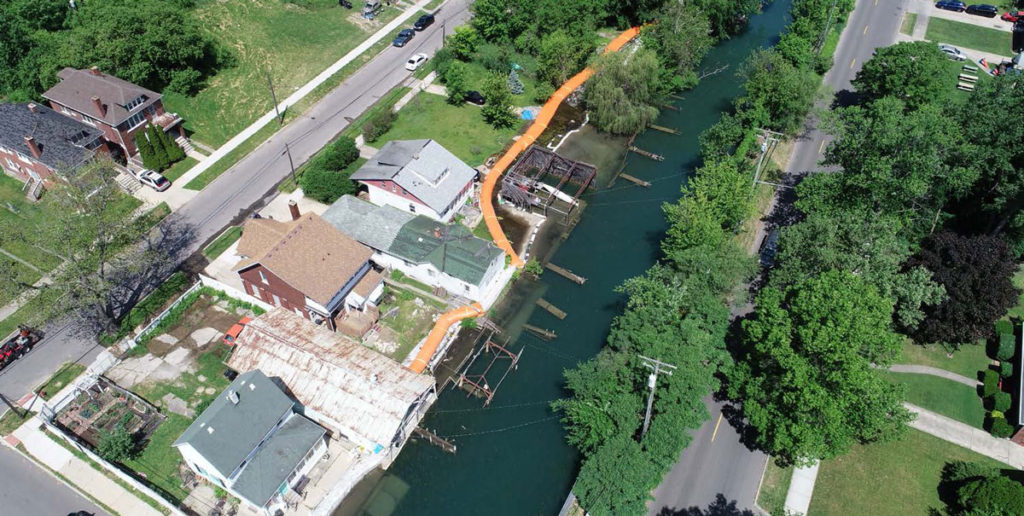
In the Jefferson Chalmers neighborhood, there is over one mile of densely packed residential properties with varying offsets to the canals. These properties also had wide-ranging edge conditions and heights of the seawalls along the canals. Some private properties had properly maintained and extended the seawalls to adequate heights, but most were non-existent or needed significant upgrades. Boat houses or other enclosed spaces also presented problems requiring barriers to be placed further away from the water’s edge. Because the rising water levels were a systematic problem for the entire neighborhood, upgrading seawalls on select lots has not solved the problems for the entire area as water will still find a low point and cause the damages described above.
Public engagement was critical to inform residents on the upcoming predictions and what would occur if measures were not taken by the community. Notifications and virtual public meetings were held to engage in active discussions in an attempt to have all members understand the significance of these measures on their property and the City’s infrastructure.
Having a proactive approach allowed the community to buy into the solution to reduce flooding amounts from the previous year. Sandbags were used the previous year that allowed many areas to stay dry, but did not fully address the problem and ultimately, just diverted it into another location and eventually into the street. The tight conditions along with limited access due to structures, fences, and other items required much further evaluation than most flood prone areas.
Elevations of expected water level compared to seawall elevations also ruled out many measures that would only provide protection for minor rises.
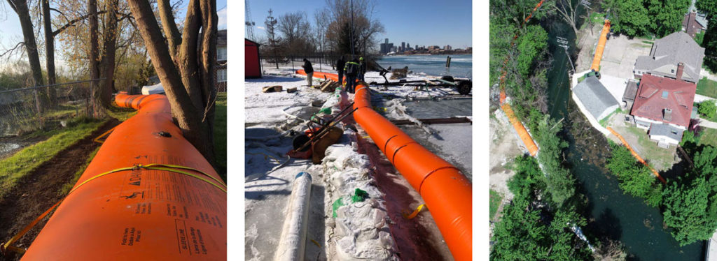
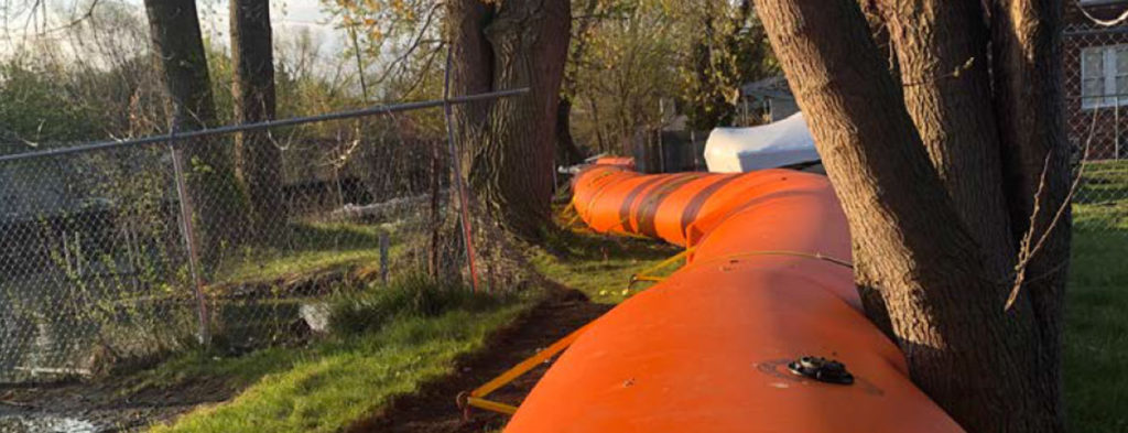
After aerial and ground surveys were complete, some areas were found to need over 4 feet in barriers for protection and an adequate safety factor. The recommended alternative chosen was an inflatable bladder system to utilize the resources already on site and readily available (canal water) and minimize disruption to each property. The bladder systems are more flexible than permanent measures to maneuver around obstacles, are offered in a variety of heights, and can be deployed and removed quickly. They also provide engineered seals between measures or abutting to other structures.
Space a Deciding Factor in Ultimate Decision on Flood Mitigation Method
The product chosen was called a Tiger Dam, manufactured by U.S. Flood Control. They specialize in flood mitigation, mostly in the coastal regions, but have experienced a higher demand in the Midwest region due to the rising water levels previously described. Space was a limiting factor, and this was a huge deciding factor for the community. These bladders also have expansion properties that can withstand freezing temperatures. This feature allowed the community the option to leave the barriers in place after the high-water levels in the summer. Leaving them in place will provide protection if water levels surge unexpectedly during the winter snow melt and also reduces labor costs to remove and replace them in the following years.
Giffels Webster has been dedicated to making communities better for over 65 years, specializing in community planning, civil engineering, landscape architecture, Geographic Information Systems, traffic engineering, and surveying.
For more information, please call Giffels Webster at 866.271.9663 and visit www.giffelswebster.com.