Data is at the heart of everything we do. At Giffels Webster, data drives the planning process from start to finish. As planners, it is important to see the whole picture before starting a project, and one tool in particular — Geographic Information Systems (GIS) — helps planners conceptualize, understand and utilize information more effectively.
GIS is a computer system for organizing, analyzing, and visualizing data or information that has a spatial or geographic component. Multiple datasets can be transformed into a visual representation, in the form of a map or an interactive suite, to help show how things are interrelated and how various components work together to shape the world around us. Through combining different pieces of information and layering them to identify overlapping patterns, relationships and trends, GIS helps answer questions and improve decision-making throughout our everyday lives.
GIS is used on a daily basis in a wide range of industries. Here are just a few examples of how it is used.
Applications of GIS in Our Communities
Planning and Design
With GIS, planners can understand a project on a much deeper level from the start. Combining aerial imagery, hydrology data, demographic data and local business data provides planners all the information necessary to understand an area’s physical, social and economic environment before the work begins.
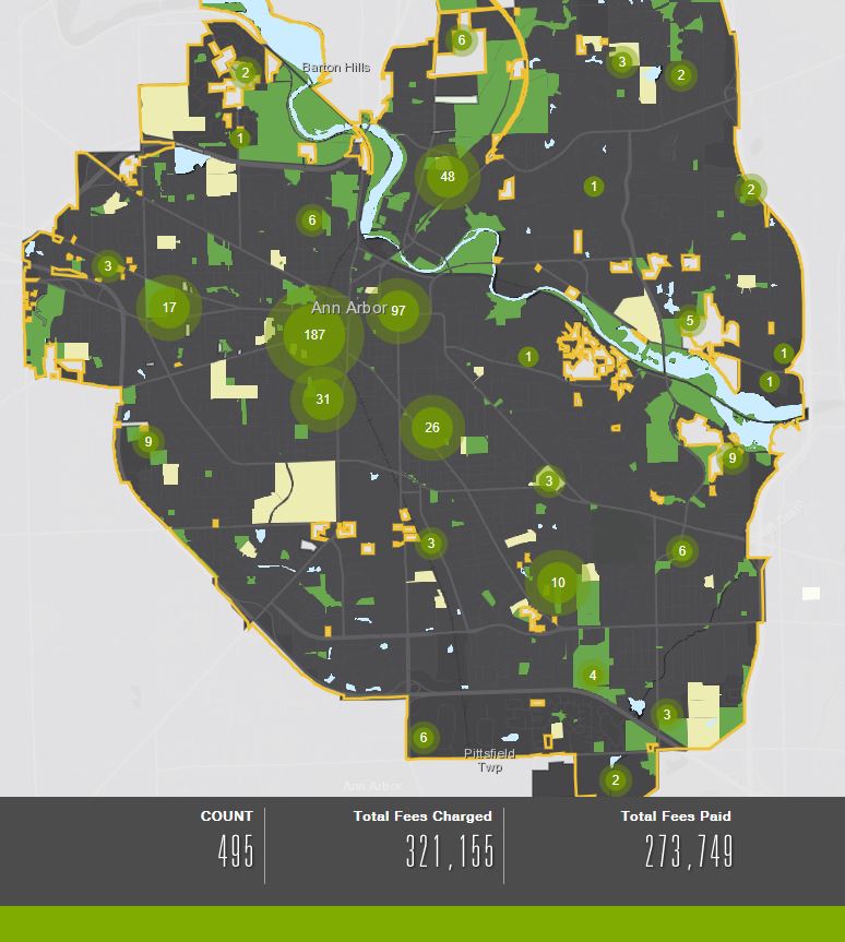
GIS provides planners an overview of past, present and future projects.
This technology can provide immediate answers to complex questions, such as how many current projects are within a specific radius of high-crime activity. As applied by Giffels Webster, GIS editing and analysis tools streamline the planning process, allowing our planners to visualize past, present and future projects at the click of a button.
Emergency Management
GIS can play a fundamental role in managing and mitigating disasters. Because it can use real-time data collected from the field to identify significant patterns, GIS applications make it quick and easy for emergency management agencies to respond to affected areas and to route resources there. The public can utilize interactive applications to find evacuation zones, shelter locations and volunteer opportunities after an emergency situation occurs.
Following a natural disaster, GIS also allows emergency management teams to conduct accurate damage estimations combining all necessary data from the field.
Local Government
GIS provides the tools for assisting citizens come election time. Using GIS, the public can find polling locations, hours of service and current wait times using interactive applications developed with the software. Leading up to an election, these applications can also provide voters insight into past election results and map out how precincts have voted in the past.
Additionally, GIS technology can provide local governments the ability to direct neighborhood concerns — like flooding or potholes — to the correct department in order to prioritize those issues on a daily basis.
Fire Departments
Using incident maps created with GIS, public safety agencies can better understand where and when crimes and fires happen. Trends can be identified through analyzing years of incident location data, which allows officials to better predict situations and utilize resources more efficiently.
GIS assists in determining the best location for new stations in a community and can help public safety officials determine how effective their current services are based on the distance between a station and various geographic points in the neighborhood.
Parks and Recreation
With a suite of real-time field data collection devices, GIS enables park management to easily monitor and maintain landscaping and irrigation systems. Interactive maps created using GIS assist the public with finding local parks and trails, campgrounds, fishing spots and swimming locations. The combination of text, multimedia and maps into one interactive application helps park managers inform, educate and engage visitors with ease.
Cemeteries
Documentation from cemeteries can be combined with aerial photography into a GIS for effective, long-term management of a property. Mapping a cemetery with GIS allows for both visitors and staff to locate existing burial sites. It also allows staff to plan for maintenance of headstones and markers and design the placement of future plots.
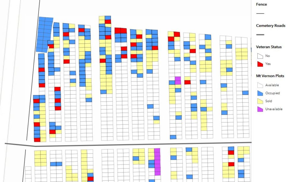
This cemetery application identifies the status and availability of plots.
Transportation
Combining accident location data and GIS can create density and cluster analyses, thus highlighting accident “hot spots” for priority management. Additionally, GIS technology enables traffic systems management and route optimization based on environmental and topographical data such as speed zones, traffic flow and the surrounding area.
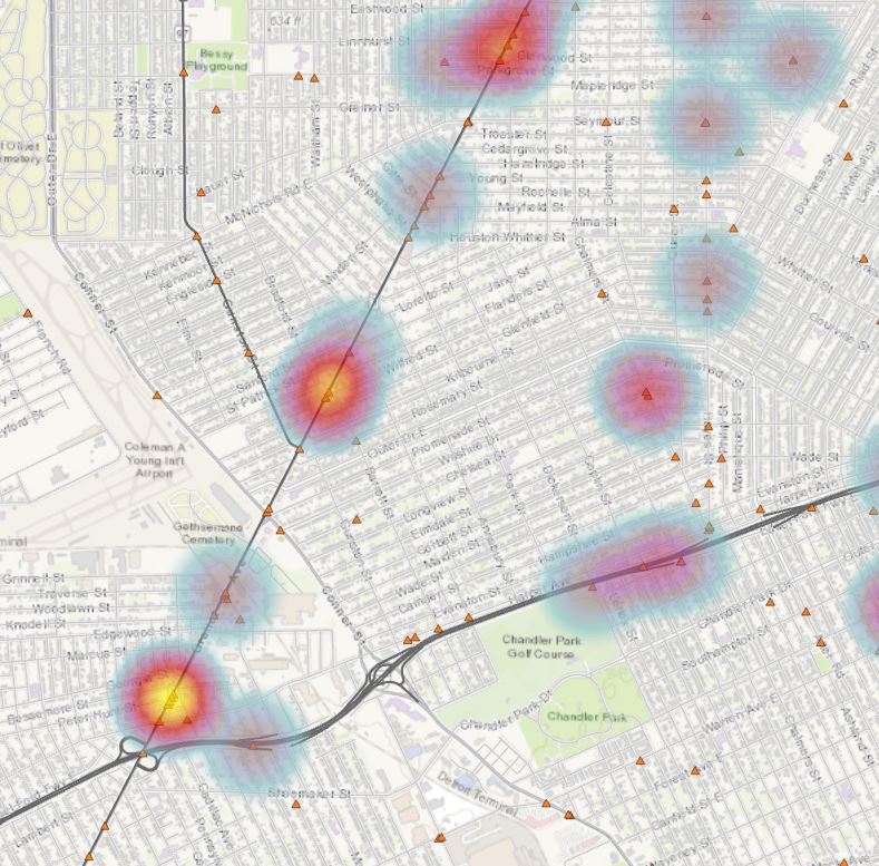
This image highlights accident hot spots through combining accident location data and GIS.
Sustainable Solutions for Your Specific Needs
At Giffels Webster, our team is focused on solution-based applications to make operations and decision-making more efficient, better informed and more cost-effective. To learn more about our GIS services and how we can serve your specific needs, contact us today.